
Little Imber on the down, seven miles from any town !
Imber is currently an uninhabited village in part of the British Army’s training grounds on the Salisbury Plain in Wiltshire, seven miles north east of the town of Warminster. The entire civilian population was evicted in 1943 to provide an exercise area for American troops preparing for the invasion of Europe during the Second World War. After the war villagers were not allowed to return to their homes and the village remains under the control of the Ministry of Defence.
 The first documentary evidence of Imber’s existence comes from Saxon times, with a mention of the village in 967. Imber is also recorded in the Domesday Book, at which time it is believed to have had a population of around fifty. The village’s church of St Giles dates back to the 12th century and has notable wall-paintings from the 15th century. By the 14th century the population of the village had risen to around 250, and eventually peaked at 440 as recorded in the census of 1851, declining to around 150 by the time of Imber’s abandonment.
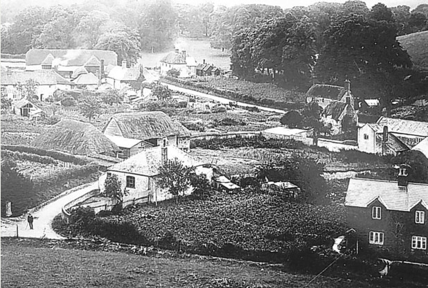
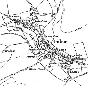
 Imber was always an isolated community, Salisbury Plain being relatively sparsely populated, and most of its residents were employed in agriculture or work that directly depended on it. The village had an elongated form like a linear village, and its main street followed the course of a stream known as Imber Dock. The only building to survive in a reasonable condition is the church, with the rest becoming derelict or demolished by the Army. In 1943 there was also a Baptist chapel (built in 1839, demolished in late 1970s), a post office, and a pub called the Bell Inn, which still stands; as does the manor house, Imber Court. Also still standing are a farmhouse, farm cottages, schoolroom and four “council house” type blocks built in 1938.
 In the late 19th century the War Office began buying land on Salisbury Plain, primarily to the east of Imber, and using it for manoeuvres. Beginning in the late 1920s farms around Imber were purchased, as well as the land on which the village itself sat. The pressures of agricultural depression, combined with the good prices offered by the military, encouraged the sale of land, with few being put off by the new conditions of their tenancy. This allowed the War Office to assume control and evict the residents if necessary. By the time of the Second World War, almost all of the land in and around Imber, with the exception of the church, vicarage, chapel, schoolroom and Bell Inn, belonged to the War Office.
On 1 November 1943, with preparations for the Allied invasion of mainland Europe underway, the people of Imber were called to a meeting in the village schoolroom and given 47 days’ notice to leave their homes. Imber was to be used by US forces to practice street fighting. Many of the buildings in Imber suffered shell and explosion damage after the war when UK military operations began, and, additionally eroded by the weather, quickly fell into disrepair. Although the villagers had been told they could return in six months, this was never allowed. At the end of the war, efforts were made to restore Imber to its pre-war condition – although there was very little damage – but the decision was taken not to relinquish control. A public inquiry also found in favour of Imber’s continued military use,but it was decided that the church would be maintained, and would be open for worship on the Saturday closest to St Giles’s day each year – a practice that continues to this day.

Imber Church (photo: Katie Pickersgill)
After the war, the village was used extensively for training, particularly preparing soldiers for their duties in the urban environments of Northern Ireland. Several empty house-like buildings were constructed during the 1970s to aid training, and it is these, along with the church, Bell Inn and Imber Court, that are Imber’s most striking buildings today.

Imber Court (photo: Katie Pickersgill). Click on the picture to see to see how it used to look in 1920.
Although training continues at Imber, a purpose-built urban warfare complex has been constructed at Copehill Down (near Chitterne) which is easier to adapt to reflect areas where troops are likely to be deployed.
How to find out more about Imber
 A more detailed history of Imber is available on the Imber Village, Abandoned Communities and TimeTravel-Britain websites, whilst further details of Imber Parish Church can be found on the St.Giles website at www.imberchurch.org.uk. However, the most definitive history of Imber can be found in the book “Little Imber on the Down” written by Rex Sawyer. Photographs of surviving original buildings in Imber can also be found here.
 Channel 5 also made a television programme on the history of Imber in 2018, which can be viewed until May 2019 on their “My5” catchup service, or on your computer by clicking here. Please note, however, that the TV crew were given privileged access to the village and ordinary visitors to Imber are not allowed to enter any of the buildings (except the church) for safety reasons.
If you are interested in transport, information on the bus services that served Imber before it was evacuated, can be found on our Imber bus history page.
If you can see anything below this line, it is an advertisement and is not related to our event, so please ignore it.
